Interface Geofence
identifier: string;
latitude: number;
longitude: number;
radius: number;
notifyOnEntry?: boolean;
notifyOnExit?: boolean;
notifyOnDwell?: boolean;
loiteringDelay?: number;
extras?: Record<string, unknown>;
vertices?: Vertices;
entryState?: number;
hits?: number;
stateUpdatedAt?: number;
}
Properties
identifier
Unique geofence identifier.
latitude
Latitude of geofence center
longitude
Longitude of geofence center
radius
Radius of the circular geofence.
⚠️ The minimum reliable radius is 200 meters. Anything less will likely not cause a geofence to trigger.
This is documented by Apple here:
"The specific threshold distances are determined by the hardware and the location technologies that are currently available. For example, if WiFi is disabled, region monitoring is significantly less accurate. However, for testing purposes, you can assume that the minimum distance is approximately 200 meters".
Optionalnotify
Set true to fire event when device enters this geofence.
ℹ️ See also:
Optionalnotify
Set true to fire event when device exits this geofence.
Optionalnotify
Set true to fire event when device "loiters" within this geofence for loiteringDelay milliseconds.
Optionalloitering
Minimum time in milliseconds the device must "loiter" within this geofence before notifyOnDwell event fires.
Optionalextras
Arbitrary key-values appended to the geofence event and posted to your configured HttpConfig.url.
Optionalvertices
Optional: a list of vertices ([ [lat, lng],...]) defining a Polygon geofence. By default, geofences are circular.
ℹ️ Polygon Geofencing is sold as a separate add-on (fully functional in DEBUG builds).
When defining a polygon geofence, you do not provide latitude, longitude or radius — those will be automatically calculated based upon the geometry of the polygon.
The following image shows polygon geofences on a map:
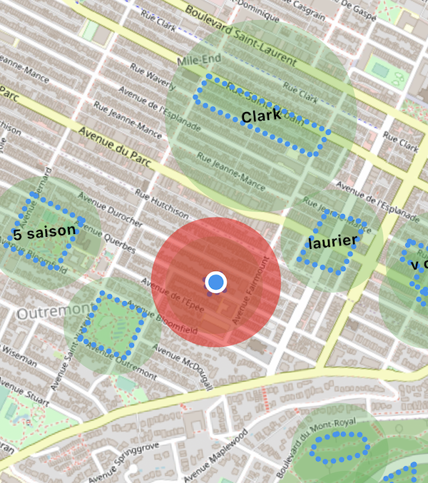
The blue polygons represent the actual polygon geofences and the containing green circles are traditional circular geofences provided by the native iOS/Android Geofencing APIs.
The background-geolocation SDK automatically calculates the containing, native cirular geofence by solving the minimum enclosing circle
for the given vertices. This is why you do not provide latitude, longitude and radius.
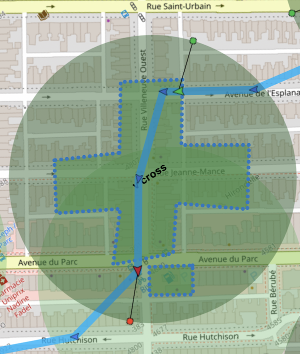
- When the device enters the containing circular geofence, the SDK uses that as a signal that the device is approaching a polygon. At this moment, the SDK begins aggressively monitoring the location to perform "hit-testing" upon the polygon using a fast algorithm implemented with C++ code.
- When the device exits the containing circular geofence, that's the SDK's signal for it to cease monitoring that polygon.
Example
BackgroundGeolocation.addGeofence({
identifier: 'Home',
notifyOnEntry: true,
notifyOnExit: true,
vertices: [
[45.518947279987714, -73.6049889209514], // <-- [lat, lng]
[45.5182711292279, -73.60338649600598],
[45.517082240237634, -73.60432670908212],
[45.51774871402813, -73.60604928622278]
]
});
- Entering / exiting a cross-shaped polygon geofence:
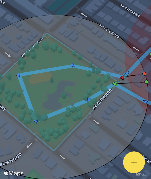
- Entering / exiting a park:
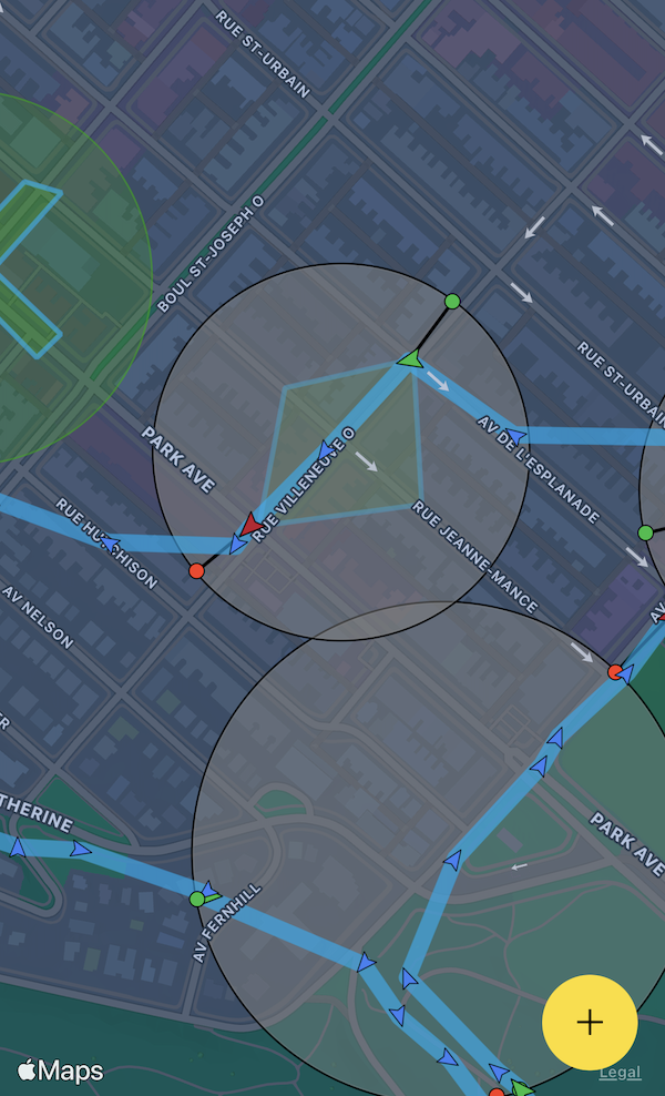
- Entering / exiting a diamond-shaped polygon:
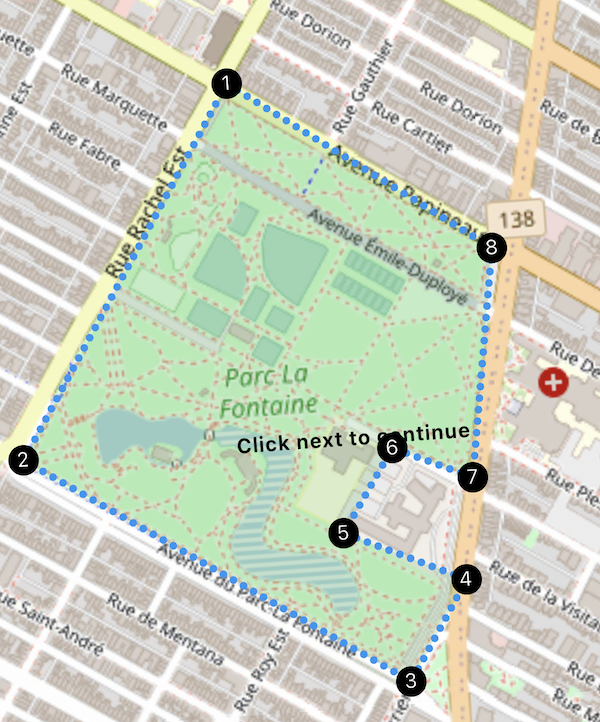
- Designing a polygon geofence around a park using the demo app:
Optional Readonlyentry
Runtime state: The current entry-state of the geofence.
- 0 = OUTSIDE
- 1 = INSIDE
⚠️ Readonly
Optional Readonlyhits
Runtime state: Number of times this geofence has been triggered.
⚠️ Readonly
Optional Readonlystate
Runtime state: Epoch timestamp (seconds) of last geofence transition.
⚠️ Readonly
The Background Geolocation SDK implements the native iOS and Android Geofencing APIs.
ℹ️ Note:
200meters.Always—When in Usewill not work.Adding Geofences
Adding a single geofence with BackgroundGeolocation.addGeofence.
Example
Adding multiple geofences with BackgroundGeolocation.addGeofences.
Example
ℹ️ Note: Adding a geofence having an Geofence.identifier which already exists within the SDK geofence database will cause the previous record to be destroyed and the new one inserted.
Listening for Geofence Events
Listen to geofence events with BackgroundGeolocation.onGeofence.
Example
Polygon Geofencing
The Background Geolocation SDK supports Polygon Geofences (Geofences of any shape). See API docs Geofence.vertices.
Infinite Geofencing
The Background Geolocation SDK contains unique and powerful Geofencing features that allow you to monitor any number of circular geofences you wish (thousands even), in spite of limits imposed by the native platform APIs (20 for iOS; 100 for Android).
The SDK achieves this by storing your geofences in its database, using a geospatial query to determine those geofences in proximity (GeoConfig.geofenceProximityRadius), activating only those geofences closest to the device's current location (according the limit imposed by the corresponding platform).
1000meters.Listening for changes in the actively-monitored set-of-geofences.
As the SDK periodically queries for geofences within the GeoConfig.geofenceProximityRadius, you can listen for changes in the actively-monitored geofences using the event BackgroundGeolocation.onGeofencesChange. This event will let you know those geofences which have begun to be actively monitored (GeofencesChangeEvent.on) in addition to those which just ceased to be actively monitored (GeofencesChangeEvent.off).
Example
⚠️ Note:
Removing Geofences
Once a geofence has been inserted into the SDK's database using BackgroundGeolocation.addGeofence or BackgroundGeolocation.addGeofences, they will be monitored forever (as long as the plugin remains
State.enabled == true). If you've configured AppConfig.stopOnTerminatefalseand AppConfig.startOnBoottrue, geofences will continue to be monitored even if the application is terminated or device rebooted.To cease monitoring a geofence or geofences, you must remove them from the SDK's database (or call BackgroundGeolocation.stop).
Example
Example
Querying Geofences
Use the method BackgroundGeolocation.getGeofences to retrieve the entire Array of Geofence stored in the SDK's database.
Example
Monitoring only geofences
The BackgroundGeolocation SDK allows you to optionally monitor only geofences without constant location-tracking. To engage geofences-only mode, use the method BackgroundGeolocation.startGeofences instead of BackgroundGeolocation.start.
Use option GeoConfig.geofenceModeHighAccuracy:true to improve the responsiveness of geofence events.
Example
Toggling between tracking-modes BackgroundGeolocation.start and BackgroundGeolocation.startGeofences
The SDK can easily be toggled between State.trackingMode simply by executing the corresponding BackgroundGeolocation.start or BackgroundGeolocation.startGeofences methods.
Example